Property Record
74 Main St, Sharpsburg, GA 30277


NEARBY LISTINGS FOR SALE OR LEASE
-
-
View all Sharpsburg listings for sale on LoopNet.com
Property Detail
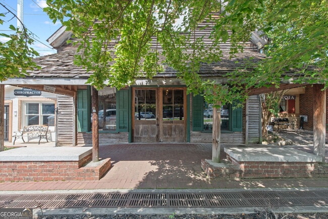
74 Main St
Atlanta-Sandy Springs-Roswell, GA
Hunters Overlook
E02-0027-005A
BUGGY MUSEUM / MAIN ST LOT
Officebuilding
Coweta
X
Georgia
13077C0291D
279
2025
0.08 AC
2025
Coweta County
170501
Atlanta
4,378 SF
DEMOGRAPHICS near 74 Main St
1 Mile
3 Mile
5 Mile
2024 Total Population
2,901
11,061
28,880
2029 Population
3,315
12,406
31,697
Pop Growth 2024-2029
+ 14.27%
+ 12.16%
+ 9.75%
Average Age
41
40
41
2024 Total Households
1,024
3,825
10,127
HH Growth 2024-2029
+ 14.55%
+ 12.34%
+ 9.80%
Median Household Inc
$97,449
$99,382
$94,253
Avg Household Size
2.80
2.80
2.80
2024 Avg HH Vehicles
2.00
2.00
2.00
Median Home Value
$329,392
$348,558
$366,741
Median Year Built
2004
2004
1999
Nearby Places
Map Layers
Map Styles
 Street
 Aerial
- Restaurants
- Banks
- Shops
- Fitness
- Groceries
PUBLIC TRANSPORTATION
AIRPORT
Hartsfield - Jackson Atlanta International
DRIVE
WALK
Distance
Hartsfield - Jackson Atlanta International
47 min
28.2 mi
SALE & LEASE HISTORY
LISTING DATE
SALE/LEASE

Aug 13, 2024
For Sale
Nearby Properties
Address
Land Use
TOTAL SIZE
Lot Size
Zoning
Address
Land Use
TOTAL SIZE
Lot Size
Zoning
115,988 SF
16.67 AC
C LUC
Address
Land Use
TOTAL SIZE
Lot Size
Zoning
93,907 SF
24.25 AC
R1
Address
Land Use
TOTAL SIZE
Lot Size
Zoning
61,637 SF
10.33 AC
R1
Address
Land Use
TOTAL SIZE
Lot Size
Zoning
78,075 SF
11.38 AC
C GC
Address
Land Use
TOTAL SIZE
Lot Size
Zoning
46,582 SF
4.51 AC
C LUC
Address
Land Use
TOTAL SIZE
Lot Size
Zoning
66,635 SF
10.90 AC
RFA
Address
Land Use
TOTAL SIZE
Lot Size
Zoning
58,800 SF
11.23 AC
R1
Address
Land Use
TOTAL SIZE
Lot Size
Zoning
13,829 SF
52.55 AC
I MI
Address
Land Use
TOTAL SIZE
Lot Size
Zoning
78,300 SF
7.49 AC
R1
Address
Land Use
TOTAL SIZE
Lot Size
Zoning
35,914 SF
64.50 AC
Address
Land Use
TOTAL SIZE
Lot Size
Zoning
234,597 SF
13.41 AC
R1
Address
Land Use
TOTAL SIZE
Lot Size
Zoning
234,597 SF
13.41 AC
R1
Address
Land Use
TOTAL SIZE
Lot Size
Zoning
86.78 AC
Address
Land Use
TOTAL SIZE
Lot Size
Zoning
6,080 SF
167.54 AC
R1
Address
Land Use
TOTAL SIZE
Lot Size
Zoning
90,884 SF
109.14 AC
M-C
Address
Land Use
TOTAL SIZE
Lot Size
Zoning
162,400 SF
10.47 AC
M
Address
Land Use
TOTAL SIZE
Lot Size
Zoning
12,527 SF
8.75 AC
Address
Land Use
TOTAL SIZE
Lot Size
Zoning
55.60 AC
Address
Land Use
TOTAL SIZE
Lot Size
Zoning
9,594 SF
2.18 AC
C GC
Address
Land Use
TOTAL SIZE
Lot Size
Zoning
42,000 SF
4.65 AC
I GI
Address
Land Use
TOTAL SIZE
Lot Size
Zoning
4,965 SF
62.66 AC
R1
Address
Land Use
TOTAL SIZE
Lot Size
Zoning
18,000 SF
18.62 AC
001
Address
Land Use
TOTAL SIZE
Lot Size
Zoning
12,530 SF
0.61 AC
R1
Address
Land Use
TOTAL SIZE
Lot Size
Zoning
16,128 SF
4.55 AC
R1
Address
Land Use
TOTAL SIZE
Lot Size
Zoning
6,576 SF
1.88 AC
C GC
Address
Land Use
TOTAL SIZE
Lot Size
Zoning
7,544 SF
2.88 AC
C
Address
Land Use
TOTAL SIZE
Lot Size
Zoning
6,228 SF
1.68 AC
C GC
Address
Land Use
TOTAL SIZE
Lot Size
Zoning
9,322 SF
96.17 AC
RFA
Address
Land Use
TOTAL SIZE
Lot Size
Zoning
10,540 SF
9.66 AC
RFA
Address
Land Use
TOTAL SIZE
Lot Size
Zoning
29,900 SF
6.35 AC
I GI
The World's #1 Commercial Real Estate Marketplace
Connect with us
© 2026 CoStar Group
The information above has been obtained from sources believed reliable. While we do not doubt its accuracy we have not verified it and make no guarantee, warranty or representation about it. It is your responsibility to independently confirm its accuracy and completeness. Any projections, opinions, assumptions, or estimates used are for example only and do not represent the current or future performance of the property. The value of this transaction to you depends on tax and other factors which should be evaluated by your tax, financial, and legal advisors. You and your advisors should conduct a careful, independent investigation of the property to determine to your satisfaction the suitability of the property for your needs.